
Death Valley National Park, Stop No. 5

November 28, 2020
Location: One way entrance off Highway 374 on east side
Vehicle: High clearance vehicles with at least 8 inches of ground clearance and 4WD or AWD are recommend
Parking: No parking for most of the road
Pets: Not allowed
Fee: DVNP entrance fee $35/vehicle good for 7 days or America the Beautiful Pass
Restrooms: No
Time Needed: 2-3 hours
After walking through the massive rock salt flats on The Devil’s Golf Course, we headed towards the Furnace Creek Visitor Center. We ensured our pass was validated and talked to the Park Rangers about what we should do. At this point it was around 9am so we still had a lot of the day ahead of us. The amazingly helpful Ranger told us about Titus Canyon in the north end of the Park. After her description and confirming our car could handle the tough terrain, we were sold and ecstatic. Because the park was so big with limited refueling options, we decided to play it safe and got gas before starting our 27 mile trek. We went about 4 miles past the entrance to Titus Canyon Road to the Nevada town of Beaty. We filled up and headed out.
Overall, Titus Canyon Road is 27 miles long. However it is one-way for 24 miles heading southwest. The last 3 miles are on a two-way road. There is a parking lot at the west entrance, and you can hike into the canyon from there. To take travel the full road by car, you enter off Highway 374.
The journey is incredible! We stopped many times, took tons of pictures, and loved every second of it. First, you start on relatively flat dirt road with early warning signs from the Park Service about unmaintained roads and unsafe passage in inclement weather. In fact, the NPS will close the road during poor conditions or road washouts. Driving west through the Amargosa Valley towards Grapevine Mountains built a lot of excited tension for us first time visitors. We knew the road would be challenging, thrilling, and time consuming… but in what way?
You enter the half billion year old rocks of the Grapevine Mountains at White Pass. At this point you’re entering upper Titanothere Canyon. According to the NPS, the “colorful rock deposits along this section contain fossil beds 30-35 million years old.” There is a spot to hike here, we didn’t, but trailhead directions are on the webpage linked in this paragraph.
Continuing on you’ll meet Red Pass after climbing a series of switch backs for cars. We dipped and crawled through the uneven eroded and rocky road. Eventually you’ll get to the top. It is the highest point on the road and it divides the two canyons. There is a hike here as well. We did not stop but saw some cars parked on the side of the road. However, the view looking back is amazing. At this point you get a glimpse of the valley sitting before the entrance to Titus Canyon. Getting down to there was a lot of fun!
As we started our descent we quickly learned this was not going to be quick. The road is not any better, if not worse at points. There are sharp turns and steep grades. Sometimes the scariest part was not being able to see the road immediately in front because of the angle of the car and the obstructed view from created by the hood. Again, it felt like we were crawling at points where all the sudden we dipped and shook as the car made its way over a rock and through dips. Occasionally we let out massive sighs of relief or picked up our jaws off floor because the views were incredible.
Twisting and turning your way downhill, you’ll soon see the remains of Leadfield – the failed mining town. The now ghost town has a very brief history but it’s quite fascinating and captures much of get-rich-quick schemes that popped up in the western expansion of the time. Without a full history lesson; the story goes that Leadfield was a false promise of lead ore and false advertising to investors. The town lasted less than a year, but it’s the reason for the road to the canyon. We stopped and looked around at what was left from 1925-1926! Almost 100 years old!
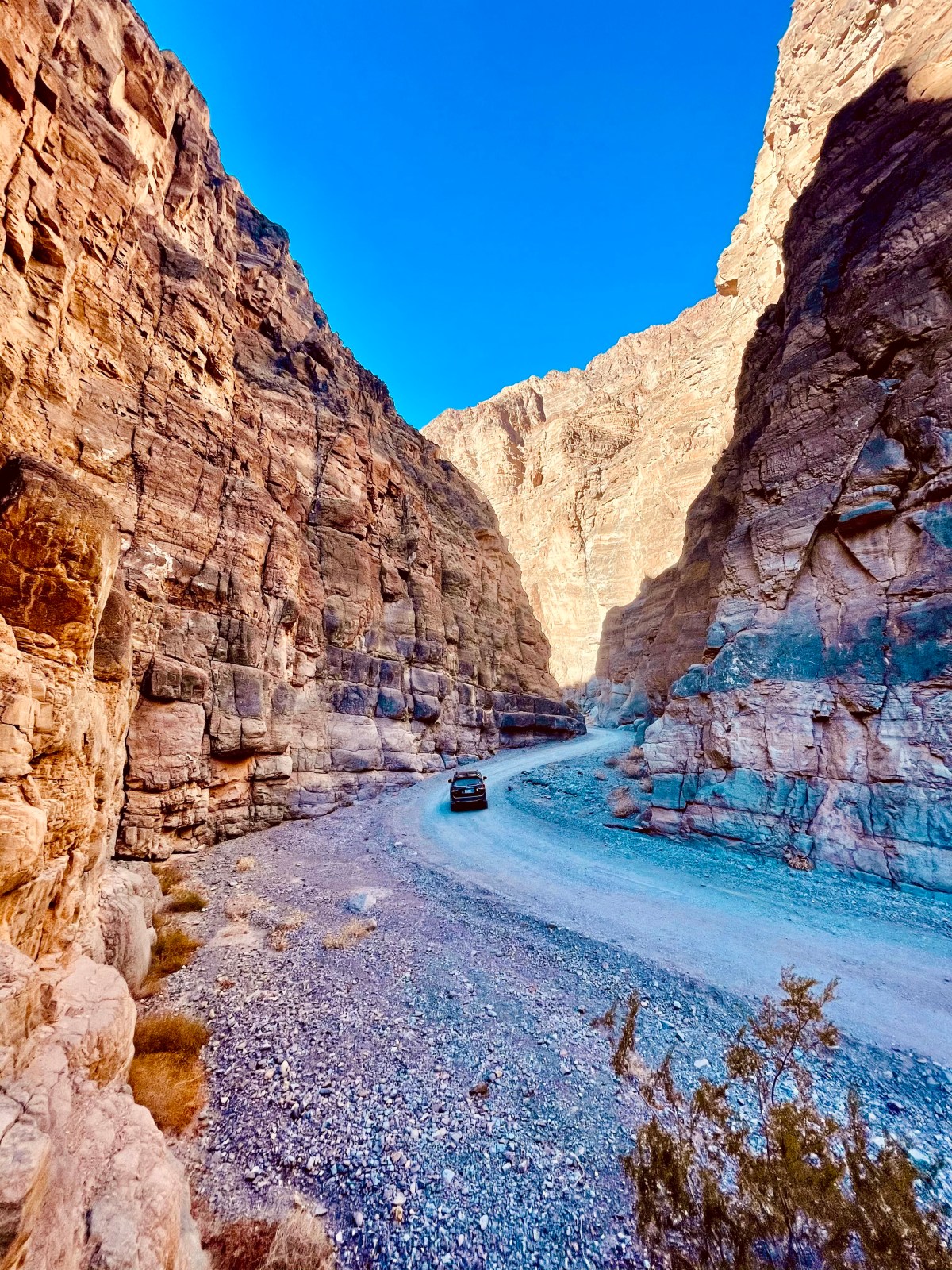
After leaving the ghost town you soon enter the start to Titus Canyon. The wash is mostly gravel and there is a good amount of vegetation, making it clear that this is a collecting point for water from rains and flash floods. It soon becomes clear that you’re in the canyon as see the limestone walls start to get higher and higher. Looking around is other worldly. You don’t feel like you’re in Death Valley anymore. The steep cliffs tower over, hide the sun at certain angles, and spew unique plants from the cracks. We didn’t see any bighorn sheep, but don’t be surprised if you see one. There are hikes here as well. A little further down there are petroglyphs from Native Americans that hunted and lived in the area.
Continuing on, Titus Canyon is full of fun twists, blind corners, and looming cliffs that look like they’re watching your every turn. Grey rock and layers throughout out are so easy to see because they become so close! In fact within the final 1.5 miles, the Canyon is 20 ft wide at its narrowest point. As you get closer to the end, depending on the time of the year, you may see many hikers. Be careful and go slow! And overall, take your time to enjoy the journey.

