
We went to Strawberry, Arizona from August 26th – August 28th. After work on Thursday evening we drove up to Strawberry and were able to work from The Strawberry Inn during the day on Friday. The Strawberry Inn is right in the heart of Strawberry and a two hour drive from Phoenix, a 25 minute drive from Payson, a 20 minute drive from Tonto Natural Bridge State Park, and a five minute drive from Pine, AZ. After our work was done we enjoyed exploring and hiking the State Park, the National Forests, and Pine Canyon Trail!

The Quick Stats | Queen Room, Main Floor
Sleeps: 2 in a queen size bed
Benefits: private bathroom, keurig, mini fridge, TV
Running water: no
Dog Friendly: yes
The Strawberry Inn
Strawberry, AZ is a very small (9.5 square miles) traffic light-less town originally founded during the western gold rush of the 1800s. The name comes from the wild strawberries that grew in the area at the time. Today, Strawberry, Arizona is known for its location on the Mogollon rim along State Route 87, all the nearby hiking, Fossil Creek, and its cooler weather relative to Phoenix.
As soon as you enter the town of Strawberry, The Strawberry Inn boutique style inn is right there on the side of the 87. The speed limit is 35 MPH so you shouldn’t blow right past it. There is a big red sign high above and really looks beautiful against the backdrop of the dark night sky. The Inn is not the only property under the Strawberry Inn name; they own and rent out individual cottages and Airstreams. However, we only stayed at the Inn and can only speak on our experience there.
The Inn was beautifully well remodeled with small little touches that really help you feel cozy and relaxed. The farm-style decor with modern amenities like individual A/C, a small fridge, coffee maker, and TV are enough modern needed for a stay tucked into Tonto National Forest where the focus should really be nature. There are some food options nearby within walking distance and a great coffee stand within the refurbished windmill on the property.
Quick Stats | Tonto Natural Bridge State Park
Distance: about 1.5 mile loop
Elevation Change: 292 ft
Difficulty: moderate
Water at Trailhead: no
Toilet at Trailhead: yes
Entrance Fee: $7/person
Dogs allowed: yes to park, no to trails

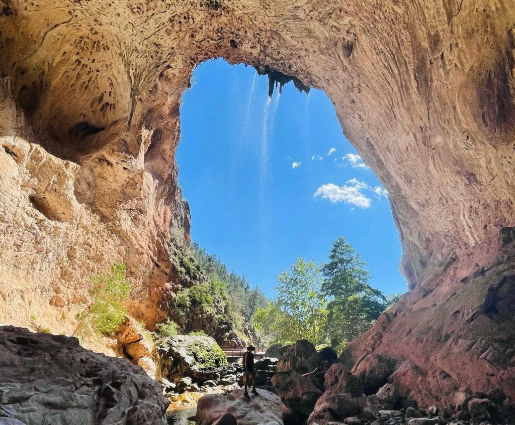
Tonto Natural Bridge
We arrived to the state park a little after 2:30pm on Friday afternoon and although the air temperature was much cooler than Phoenix, it was still warm out. Around 2:45pm we started hiking at the west end of the State Park and hiked down Gowan Trail, under Tonto Natural Bridge and then along Pine Creek Trail up and out Pine Canyon. In total we recorded 1.54 miles with stopping at the waterfall trail that added about 0.2 miles.
Overall the hike was technical as foot placement was critical when walking under the bridge and over the large boulders. Then as we walked up the creek the large boulder crossing continued. We never felt physically out of breath or hurting, but we definitely had to pay close attention to where we were stepping our use other rocks and logs to help pull us up. You can tell that the flash floods of the monsoons have quickly displaced and moved natural debris. Normally there is another trail that you could take to get out of the creek, but previous storms and ruined the trail and it was closed by the park.
Tonto Natural Bridges is one of the world’s largest known natural travertine bridges. It’s 150ft wide, 183ft high, and 400ft long. You can view from above or hike down to base and back up.
Quick Stats | Pine Canyon Trail: short out & back
Location: North of Strawberry, AZ off of Highway 87, Coconino National Forest Google Maps |AllTrails
Distance: 1.2 miles out & back
Elevation Change: 213 ft.
Difficulty: Easy
Toilets at TH: No
Water at TH: No
Trash Receptacle at TH: No
Dogs Allowed: Yes
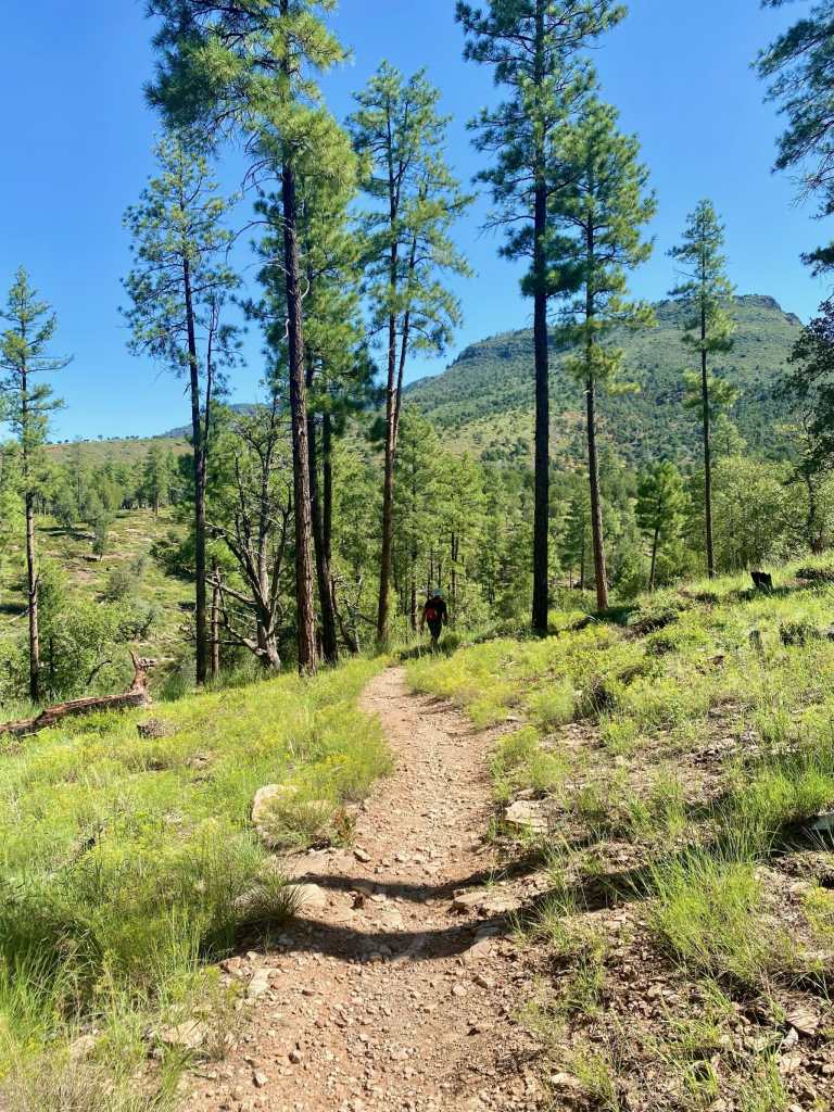
Pine Canyon Trail: Short Out & Back
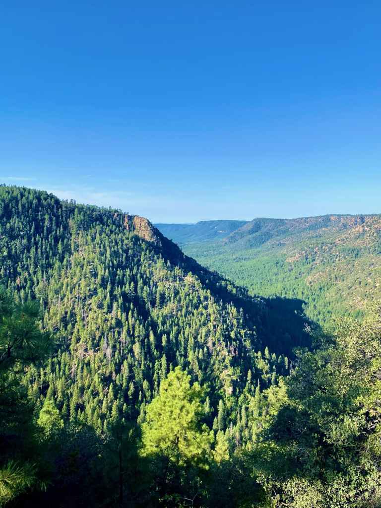
Pine Canyon is a beautiful Ponderosa Pine filled canyon between Pine, AZ and top of the Mogollon Rim where Highway 87 traverses. Running through the canyon is Pine Creek, which continues south to Tonto Natural Bridges State Park. Pine Canyon Trail #26 goes from Pine, AZ in the Tonto National Forest up to the top of the Canyon which is where the Tonto NF boarders the Coconino Nation Forest; this is where we started. It’s 10.5 miles long with 803 ft elevation gain if you travel from the Rim to Pine, AZ.
All Trails: One Way | Out & Back
We did not do the full trail that August morning and instead opted for this easy 1.2 mile out-and-back portion of the trail. It runs from the pull off of the 87 to top of the canyon with a beautiful overlook. It’s downhill towards the canyon and slightly uphill on the way back. As you head out you’ll come across a sign with some trail info. You can also hike down to the canyon and back up. We aren’t sure how long that is distance wise, but we think it’s something we’ll do next time, or possibly do the thru hike if we can arrange to be dropped off and picked up.
Quick Stats | Pine Loop Trail
Location: Pine, AZ, Tonto National Forest Google Maps |AllTrails
Parking lot: Yes
Distance: 2.7 miles loop
Elevation Change: 360 ft.
Difficulty: Easy
Toilets at TH: Yes
Water at TH: No
Trash Receptacle at TH: Unsure
Dogs Allowed: Yes, leashes required
Bikes Allowed: Yes
Pine Loop Trail
Now at the opposite end of the trail we were on earlier in the morning, we started on the Pine Canyon Trail #26 to do a loop including trail #28 and the Highline Trail #31, which is part of the Arizona Trail. We went slightly beyond the loop laid out on All Trails, and hiked on the Highline Trail for a little bit until we felt like turning around. This trailhead is relatively popular as there are multiple trails to take and it’s an easy place to hop on and off the Arizona Trail or hike a portion
This loop is relatively easy but can be made more moderate if you add your own distance and do some out-and-backs along trails involved. The trail is mixed with shade and exposed parts. The summer of 2021 was full of monsoons and area was full of green views with Ponderosa Pines towering above and trees, grass, cacti, and other healthy vegetation below.


