

Canyonlands National Park, Arches National Park, Moab

4 Days, 3 nights glamping, hiking, driving, exploring and more…
Summary
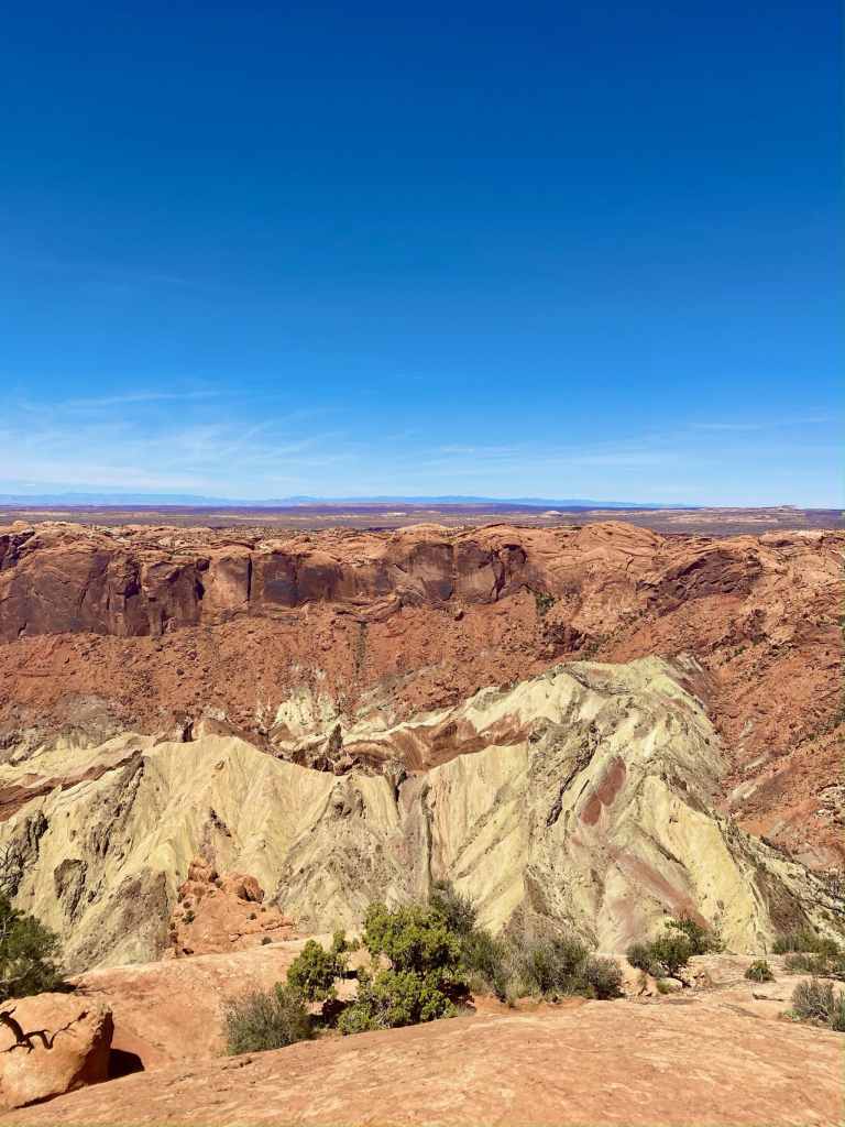
We understand why people love Moab, UT. It’s a simple sentence for a sophisticated region of the country. The Moab area is stunning landscape with the Colorado and Green Rivers carving their way through the 100+ million year old sand stone. There are arches galore, even a whole National Park dedicated to them. The needles, plateaus, canyons, arches, and rock formations that make up the massive Canyonlands National Park will leave you awestruck. The beautifully weathered red rock landscape can make you feel so isolated, small, and thankful for Mother Nature. Stories and video might not do this place justice. Moab is truly a playground full of hikes, backcountry camping, scenic drives, and much more.
Most of our trip was on foot, hiking on trails, or in the car on paved road. Moab is also extremely famous for its OHV trails, especially famous Jeep trails now tested by Wranglers and other off-road capable vehicles. We explored some of the Needles District and Island in the Sky District of Canyonlands National Park; then we explored much of Arches National Park and still have much more to see; and after we drove along the Colorado River and explored some Bureau of Land Management public lands. Our entire trip was anchored by our stay at Glamping Canyonlands, 45 min south of downtown Moab, UT.
Getting Here
Our entire trip was on Google Maps. And by that we mean all locations are on the app. However, service is very limited in much of the area so we downloaded the area to offline map. This feature downloads the portion of the map you selected to your phone, allowing you to search an area without service and still have directions generated. We took the fasted route to Glamping Canyonlands. On our way back to Phoenix we stopped at Natural Bridges National Monument and took the Moki Dugway down to Monument Valley, which was different from our drive to Utah.
Our Itinerary
Thursday, Day 1
Canyonlands National Park – The Needles District
POI: Druid Arch
Hike: Druid Arch Trail
Trailhead: Elephant Hill parking lot
Restrooms at Trailhead: yes
Length: 11 miles out and back
Difficulty: moderate
After we arrived at our glamping stay at Glamping Canyonlands we met our amazing host and then got on our way to the Needles District. Unfortunately for us the State of Utah was in the process of resurfacing their portion of the 211. Because of this they closed the road to one lane and we were stopped as we waited our turn for 45 minutes. By the time we got to the Elephant Hill Trailhead it was 4:00 pm and we were on our way less than 15 minutes later. To drive down Elephant Hill Road further, a permit is required. To backpack camp and leave your car at the Elephant Hill Trailhead, a permit is required.
This hike is incredible! Early in to the hike you can see some of the “needles” of the park and how the district got its name. As you walk along the mesa type area you slowly decent, eventually coming to the wash portion of Elephant Canyon. Much of the hike is along the wash and it’s gorgeous! Every turned corner is a photo opportunity. The towering cliff sides and needles make you feel so small. We recommend having the trail downloaded however you prefer. We use AllTrails Pro. At some points the trail goes along the side the wash, which is critical because the wash is impassable at points. Towards the very end of the trail is a metal later and railing installed by the NPS to help you up. At that point the Arch is visible. Soak it in!
Friday, Day 2
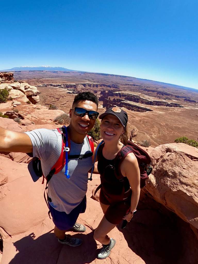
On our 2nd day we decided NOT to get up before sunset just to drive 90 minutes to Mesa Arch to capture it with the sunrise. It was nice to “sleep” in a little. Below is our itinerary for the day. Island is the Sky District is closer to Moab than the Needles District is. You have to drive through Moab to get to Island in the Sky.
Canyonlands National Park – Island in the Sky District
POI: Shafer Canyon Overlook
Trailhead: soon after the the visitor center there is a parking lot
Length: 0.3 mile hike out to overlook
Hiking difficulty: easy
Drive: 19.6 miles point to point
Drive conditions: Dirt Road, 4WD required
Canyonlands National Park – Island in the Sky District
POI: Mesa Arch
Trailhead: parking lot
Hike: loop style
Length: 0.7 miles
Difficulty: easy
Restrooms at Trailhead: yes
Canyonlands National Park – Island in the Sky District
POI: Grand View Point Overlook; great views of the national park
Trailhead: Parking lot
Hike: out & back
Length: 1.8 miles
Difficulty: easy
Restrooms at Trailhead: yes
Canyonlands National Park – Island in the Sky District
POI: Upheaval Dome
Trailhead: Parking lot with shared picnic area
Hike: out & back
Length: 0.6 miles O&B to 1st Viewpoint | 1.2 O&B to 2nd Viewpoint
Difficulty: moderate (mostly incline)
Restrooms at Trailhead: yes
After a long day at Canyonlands National Park we made a quick stop at the Arches National Park Visitor Center and then went out to see Delicate Arch from a distance.

Arches National Park
POI: Upper Delicate Arch Viewpoint
Trailhead: Parking lot
Hike: out & back
Length: 0.7 miles
Difficulty: easy to moderate (incline)
Restrooms at Trailhead: yes
Saturday, Day 3
On Saturday we were up early, packed and ready to go before 6:30am. We were at the park by 7:30am. For us it was perfect timing because we missed the sunrise crowd plus lines, and we were able to go straight to the parking lot at Devil’s Garden. We found a spot without a problem! However, by the time we were back at our car around 11am, there was a long line of cars waiting for our spot or others to open. Here was our itinerary for the day.
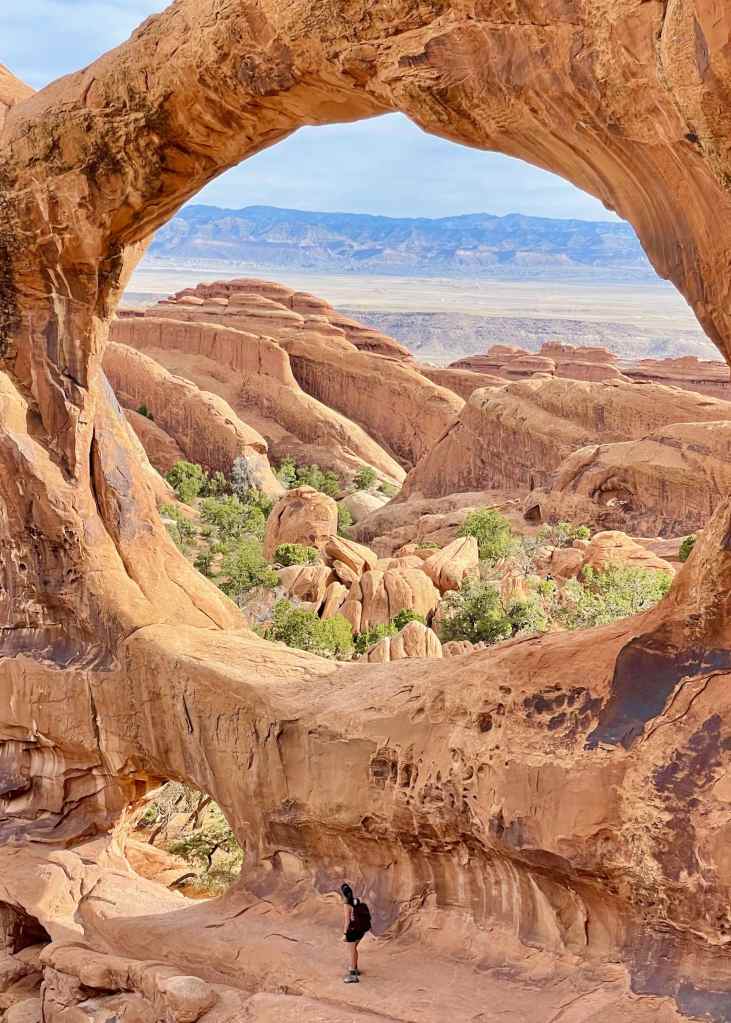
Arches National Park – Devil’s Garden
POIs: Double-O Arch, Landscape Arch, Private Arch, Black Arch Viewpoint, Pine Tree Arch, and Tunnel Arch. We did not go to Navajo Arch or Partition Arch
Trailhead: Large Parking Lot
Hike: out & back or loop via primitive trail
Distance: 4.2 miles out and back. Seeing some of the other arches added 0.5 miles
Difficulty: moderate (incline and uneven)
Restrooms at Trailhead: yes
Nearby: Skyline Arch


Arches National Park – Windows Section
POIs: Double Arch, Parade of Elephants, North Window Arch, South Window Arch, Turret Arch
Trailhead: Large Parking Lot
Hike: out & back and loop with additional primitive trail loop option (1.2 miles)
Distance: Double Arch 0.6 miles + Windows Loop 0.7 miles
Restrooms at Trailhead: yes
Double Arch AllTrails | Windows Loop AllTrails
Google Maps: Double Arch | Windows
After about 7 hours at Arches National Park we took a drive, east along the Colorado River on the 128. It’s such a beautiful drive through the deep, water forged canyon along the banks of the river. After the drive we went into downtown Moab. The small town of 5,000+ residents is cute with many small shops, boutiques, and places to eat. They see 3+ million visitors a year! We grabbed a late lunch then checked out the shops with a few purchases. To top off the day we went out to Corona Arch on BLM land also along the Colorado River. There are tons of campsites, boat launches, and even rock climbing options. We can easily see why so many people travel to and adventure to Moab.
Corona Arch and Bowtie Arch – Bureau of Land Management
POIs: Corona Arch, Bowtie Arch, Pinto Arch
Trailhead: gravel parking lot
Hike: out & back
Distance: 2.4 miles
Difficulty: moderate
Restrooms at Trailhead: yes
Sunday, Day 4
On our way home we planned to stop at Natural Bridges National Monument. This location was the first ever Utah park to become part of National Park Service, in 1908. This small secluded National Monument was 100% worth it. Most natural bridges have an easy and short to get to view point off the road. We went down the bottom of the largest bridge, Sipapu. The hike down was fun and required a few ladders. From the bottom you can walk along the canyon floor from bridge to bridge. It’s a primitive trail and considered strenuous by the park service. On our way home we took the 261 Moki Dugway south down past the entrance to Valley of the Gods and the turn off to Goosenecks State Park. Once we connected to the the 163 past Mexican Hat. From there we drove through Monument Valley.
Natural Bridges National Monument – Sipapu Bridge
Trailhead: small parking lot, designated spots
Hike: out & back
Distance: 1.2 miles
Elevation change: – 436 ft
Difficulty: moderate
Restrooms at trailhead: no


