
Spencer Trail
Marble Canyon, AZ
Lees Ferry has a rich history and somewhat controversial. We encourage you to read some of the history here. And to read more about the area on the Glen Canyon National Recreation site here. The National Park website is a great resource with additional links and information about the entire National Recreation Area.

The Quick Stats
Distance: 4 miles out & back
Elevation change: 1,700 ft
Type: Maintained trail with switchbacks and sand. Narrow at times
Restrooms at the Trailhead: yes
Water at the trailhead: no
Dogs allowed: yes, but we wouldn’t recommend
Parking lot: yes, medium size
Hiker’s ledger: no
Fee: $30 vehicle fee to enter Glen Canyon National Recreational Area or America the Beautiful pass/other annual passes. Check with the website here for more information
Getting here
Lees Ferry isn’t super well known to the average person or traveler. However, many in the Arizona exploring, hiking, and rafting community may know of it and its location. Lees Ferry (the boat/raft ramp) is located at the end of Lees Ferry Rd. (also known as Honey Moon Trail). The only way to access Lees Ferry by car is from Arizona State Route 89A, about 45 min south of Page, AZ. The 89A runs through Marble Canyon, AZ – which is where you’ll find the Navajo Bridge. Lees Ferry is quite simple to find using most map applications by just typing the name in. Spencer Trail is at the very end of the road and uses a dirt parking lot. You can also search ‘Spencer Trail Lees Ferry’ or Spencer Trailhead. We’ve lined the Google Maps location here:
Spencer Trailhead (36.86648775171967, -111.58378585566311)
Don’t forget to display you permit!
The hike
Spencer Trail is a relatively short trail, but gains some serious elevation in that short amount of time. The hike starts out among the remnants of Lonely Dell Ranch and the steamboats from 1910 left by Charles Spencer, a gold miner. Soon you start to hit the switchbacks and the steady incline begins. The trail stays wide a the start but gets narrow at points
As you get higher on the trail the sheer steepness of the cliff sides becomes apparent. If you’re afraid of heights, don’t look down! The trail is fairly easy to follow, if you go off trail, you’ll most likely go off the side of the cliff. However, as you continue up the switchbacks there is an increasing amount of sand from rock erosion on the trail. The sand does make traction difficult as it sits on top of large rocks that form the corners of the switchbacks. So as you step on the rocks and your foot slips a little with the view of impending death below, GO SLOW! Sometimes there is a series of steps built out of the rocks with a layer of sand covering them.
Once you’re at the top of the of the canyon, Spencer Trail Lookout, there are multiple paths to follow. To get a great overlook of Lees Ferry, head towards cliff edge and you’ll see a great view of the Colorado River bending below. We also confirmed with one of the Park Rangers that you can hike to the inside of Horseshoe Bend from here. It is a much longer hike than you’d expect based off a map because the terrain is not always flat. There is a lot of zigzagging required.


Cathedral Wash Trail

The Quick Stats
Distance: 3.3 miles out & back
Elevation change: 387 ft
Type: unmaintained trail wash
Restrooms at the Trailhead: no
Water at the trailhead: no
Dogs allowed: no
Parking lot: no. parking is on the side of the road, but doesn’t allow for a lot of cars
Hiker’s ledger: no
Fee: $30 vehicle fee to enter Glen Canyon National Recreational Area or America the Beautiful pass/other annual passes. Check with the website here for more information
Getting here
Instructions for getting to Cathedral Wash Trailhead are similar to Spencer Trailhead, but do not require you to drive all the way down Lees Ferry Rd. The parking is located just off the road and requires parallel parking. This trailhead is marked by the National Park Service and easy to find on a map application. We’ve linked the Google Maps location here:
Cathedral Wash Trailhead (36.83456642501909, -111.63820944191141)
The hike
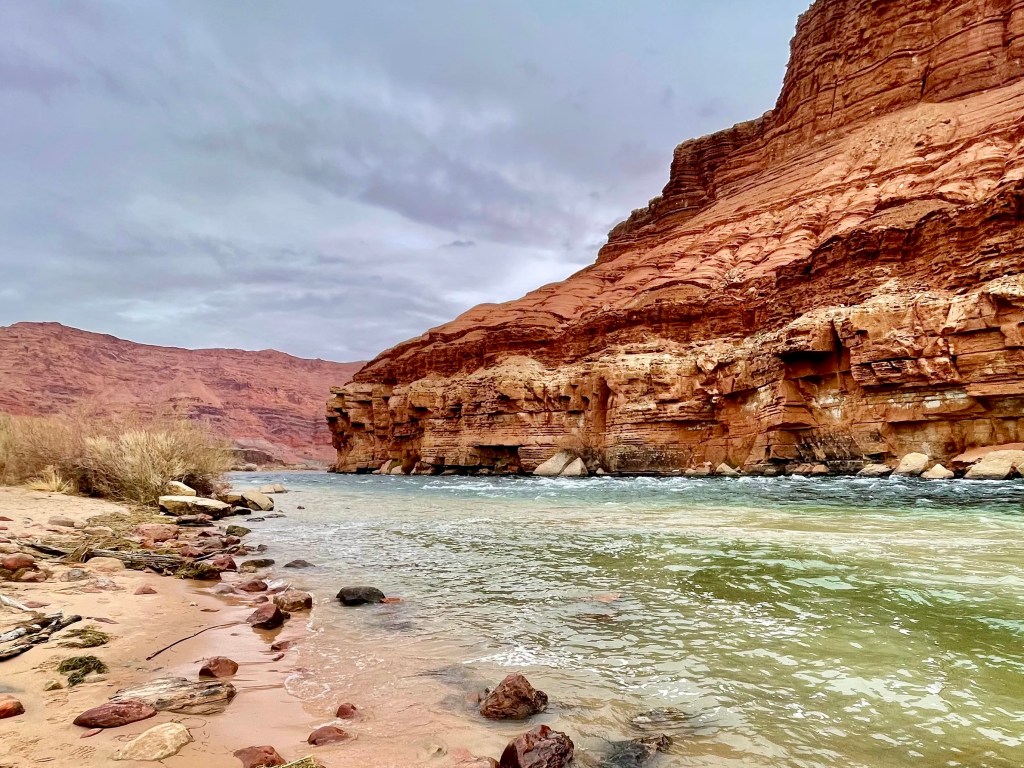
The hike through Cathedral Wash probably can’t be captured by words, it’s that stunning. As you work your way down the 1.5 mile trail, you continue to decline in elevation as you get closer to the Colorado River. At many times, the jaw dropping beauty of the towering cliffs shaped by Mother Nature make you feel so small. As we walked down the wash it was hard not to think about the time it took for the wash to form and the power of water and wind on the Navajo Sandstone.
There is a fantastic description in the AllTrails App on how to best navigate the trail. This is what we followed and recommend it to those visiting for their first time too!
There is one major drop off that looks intimidating at first, but after reading the description, it wasn’t too difficult. There is a spot where you can slowly descend down to the rock layer below, and then you duck under a “tunnel” to continue down the trail. For most of the trail, our best advice is to STAY RIGHT. We continued to ask ourselves, can we get back up this way?? Our goal was to come back the way we came. With that being said, there is an important part of the trail where crossing over to the left side is best and easiest. It’s towards the end after you go around this towering bend in the wash seen in the photo below. After crossing over you’ll stay left until the wash starts to open up. At this point you’re very close to the Colorado River and should be able to hear the rapids.

Click through below to see images from our hike.


