Hike Black Top Mesa: Superstition Wilderness

Black Top Mesa: Superstition Wilderness

The trail to Black Top Mesa is a demanding and rewarding hike in the Superstition Wilderness of Tonto National Forest. The challenging hike combines a long approach on Dutchman Trail #104 from First Water Trailhead with a steep final climb via Bull Pass Trail #129 to the mesa’s dark basalt cap. Expect rugged, rocky footing, little shade, and big scenery—views into Boulder Canyon and La Barge Canyon, with Weaver’s Needle dominating the skyline. The ascent gains roughly a thousand feet in about a mile, making this a true workout even for experienced hikers. Go in the cooler months, start early, carry plenty of water, and stay on established paths to protect this recovering desert landscape.

Need to Know

This is the Sonoran Desert, home to many sharp and spiny plants, venomous reptiles and spiders, and larger wildlife like mountain lions, coyotes, and bighorn sheep. Pay careful attention to your surroundings and always hike snake aware. The Superstitions are remnants of volcanic activity. The rocks are sharp, jagged, and large. We highly recommend stable footwear with good protection.

Superstition Wilderness Area

This entire hike is in federally designated Wilderness Area, meaning it’s closed to all motorized equipment and bicycles. Hikers and horseback riders are allowed, and on weekends there is a good chance you’ll see horseback riders. Most importantly, this area is closed to drones

Black Top Mesa from First Water Trailhead

There are several ways to reach Black Top Mesa, but the most straightforward approach starts at First Water Trailhead on First Water Road (Forest Service Road 78). The turnoff from State Route 88, the Apache Trail, is just north of the entrance to Lost Dutchman State Park. The road is dirt with some ruts and rocks, but usually passable for a sedan if you drive slowly and watch for dips.

You may also see this trailhead listed as Dutchman Trailhead on maps. It sits at the very end of First Water Road. If the main lot is full, there is an overflow lot for horse trailers a short distance back with a signed connector path to the main area. Both lots have vaulted toilets.

Quick Stats
Length:

11.7 miles

Route Type:

Out and back

Elevation Gain:

1,981 ft

Vaulted Toilets:

Yes

Dog Friendly:

Yes

Fee:

No

Difficulty:

Hard

Water:

No

AllTrails:

Hiking Black Top Mesa

From First Water, begin on Dutchman Trail #104. You will stay on Dutchman for most of the approach with a few signed junctions early on. Shortly after starting, ignore the left fork to Second Water Trail and continue straight on Dutchman.

Around four miles in you will reach a cluster of junctions:

  • About 4.3 miles: junction with Black Mesa Trail #241 — continue straight, staying on Dutchman Trail #104

  • About 4.4 miles: junction with Boulder Canyon Trail #103 — continue straight on Dutchman Trail #104

  • About 4.5 miles: junction with Bull Pass Trail #129 — turn left onto Bull Pass Trail. Dutchman turns right and heads south here

Once on Bull Pass Trail, you are at the base of Black Top Mesa and the climbing begins in earnest. The trail rises quickly to a saddle, then an unsigned path heads right up the mesa. Expect roughly a thousand feet of gain in about a mile with grades near twenty five percent. The dark basalt rock that gives the mesa its name contrasts beautifully with green desert plants and stacked boulders from ancient volcanic activity.

On top, catch your breath and look back into Boulder Canyon and La Barge Canyon. Continue south along the mesa and you will find a few flat spots suitable for backpacking. Views of Weaver’s Needle dominate the skyline. At the south edge you can look down on Dutchman Trail and its junctions with Peralta Trail #102 and Terrapin Trail #234.

Recent wildfire scars are visible in parts of the Superstition Wilderness. Please stay on established paths, avoid stepping on recovering vegetation, and pack out everything you bring.

More Hikes in Phoenix & The Superstitions

If you enjoyed Black Top Mesa and want more desert routes from quick climbs to full day outings, check our guide to hikes near Phoenix for additional trails, logistics, and planning tips. Below are some of our other favorites and challenging hikes in the Superstition Mountains and Wilderness of Tonto National Forest.

5 Best Hikes in the Superstition Mountains

This guide highlights the five best hiking trails in Arizona’s Superstition Mountains, showcasing stunning views, diverse terrains, and varying difficulties. It emphasizes outdoor ethics and provides specifics on each trail, including distance, elevation, and amenities. The trails cater to different experience levels, ensuring memorable adventures in the desert landscape.

Read More »

Battleship Mountain Scramble: Superstition Wilderness Hike

Battleship Mountain is a tough but rewarding hike in the Superstition Wilderness near Phoenix. Starting from First Water Trailhead, the 12-mile round trip involves tricky scrambles and stunning views. Just watch out for sharp rocks and wildlife, and remember to pack plenty of water. It’s not for beginners, but definitely worth it!

Read More »

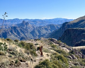
Superstition Ridgeline Trail: Superstition Mountains

The Superstition Ridgeline Trail in Tonto National Forest is an unofficial but popular 11.25-mile hike with challenging sections and stunning views. It’s mostly exposed, so be prepared for little shade and some tricky scrambles. Don’t forget your hiking poles for the descent and watch out for wildlife!

Read More »
Hi There!

We're Lauren and Owen -

We started The AZ Hikeaholics as a way to share our adventures with an audience that was interested. It soon grew into a community and we were all in! The more we learned about the history, geology, culture, biology etc, of the places we were exploring, the more we wanted to know.

You may also like -

Join our mailing list!

Never miss an update

Stay up to date by subscribing to our mailing list to receive our monthly newsletter and other important updates!