


Moab, Utah is one of the best adventure destinations in the Southwest, and it’s home to two incredible national parks — Arches National Park and Canyonlands National Park. From iconic arches and eroded red rock formations to sweeping canyon views carved over millions of years, the landscapes here never get old.
Over Thanksgiving weekend, we planned a 3-day Moab trip to explore both parks. Thanksgiving has become our tradition for travel since it gives us a long weekend without using PTO, and this time we left on Thursday to maximize our time. Returning to Moab reminded us why this area is so special — the mix of world-class hiking, geologic wonder, and deep cultural history makes it a destination worth visiting again and again.
Please remember to practice the LEAVE NO TRACE principles. Stay on trail, pack out all trash, and explore prepared. Don’t carve into any rocks. It is illegal! Check out our hiking tips here.
Just outside of Moab, Utah, you’ll find Arches National Park and Canyonlands National Park. These two parks are completely different in scale and scenery, yet both are must-sees when visiting Moab.
Arches National Park is the more popular of the two, and for good reason. The park has the highest concentration of natural stone arches in the world, along with windows, spires, pinnacles, and unusual rock formations that create some of the most iconic desert landscapes in the Southwest. Arches is also relatively small, making it easy to explore in a day or two, with plenty of hikes that showcase its unique scenery.
Canyonlands National Park, on the other hand, is vast, remote, and divided by the Colorado and Green Rivers. It is split into four districts, with the Island in the Sky District northwest of Moab and the Needles District about an hour south. Canyonlands is one of our favorite parks for its wide range of adventure opportunities including short day hikes, multi night backpacking trips, scenic 4WD routes, and jaw dropping overlooks carved out by millions of years of geology. We have only explored two of the districts so far, but hope to experience them all one day.
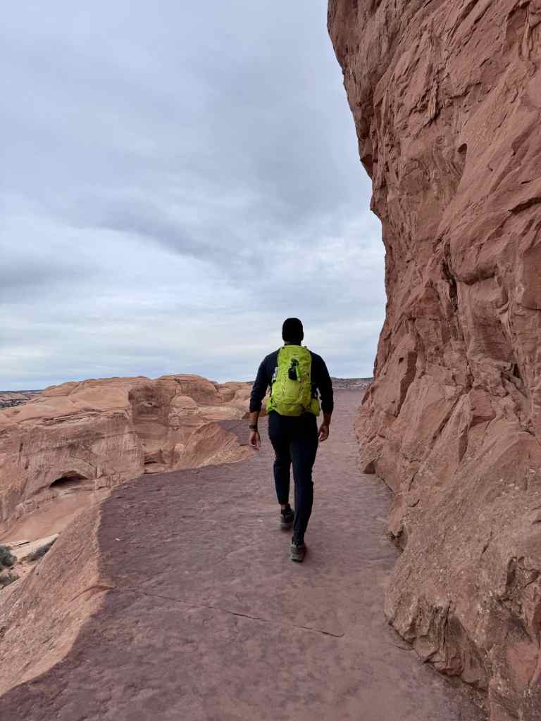
On Thursday morning we hit the road early so we could squeeze in a hike before our dinner reservations. The last time we visited Moab and Arches, we didn’t hike to the famous Delicate Arch. This time, it was at the top of our list. From Phoenix, we drove about 7.5 hours directly to the trailhead. The arch was stunning to see in person, especially up close. It completely lived up to the hype and all the photography we had seen.
The hike started off easy but quickly became more challenging as we gained elevation. Some parts of the trail were steep and narrow, which slowed us down with our camera gear. Once we reached the arch, the views were breathtaking. It’s one thing to see Delicate Arch in pictures, but standing beneath it gives you a whole new perspective of its size and the dramatic landscape around it. Despite the crowds, it was absolutely worth it.
After our hike, we headed back to our hotel to clean up and get ready for the evening. Since it was Thanksgiving, we had booked a buffet dinner at Wyatt’s Grill, hosted in the ballroom of The Hoodoo Hotel. We weren’t sure what restaurants would be open in Moab for the holiday, so the buffet felt like the safest choice. It ended up being perfect — a traditional Thanksgiving dinner with all the classics, which made it feel festive even though we were away from home.
On Friday, we headed back into Arches to tackle the West Salt Valley Jeep Road. This route requires a high-clearance, 4WD vehicle with low-range gearing, so it’s definitely not for every car. From the Main Park Road, we turned onto Salt Valley Road, an unpaved stretch, before reaching the north end of West Salt Valley Jeep Road. Before starting, we aired our tires down and got ready for the obstacles ahead.
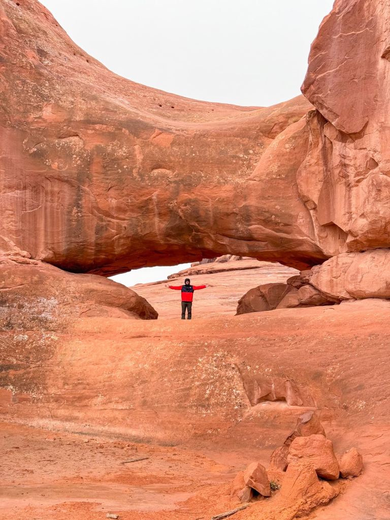
The first section is the toughest, with most of the rock obstacles appearing early on. If you check a park map, you’ll see that the road forms a T-shape. Our first stop was the Tower Arch Trailhead, which branches off the jeep road. From there, it’s only about half a mile out and back to reach Tower Arch. If you don’t have a 4WD vehicle, you can still hike to the arch from Klondike Bluffs Road, which makes the route about 2.4 miles round trip.
After hiking to Tower Arch, we drove back to the main section of the jeep road and turned south. This portion had a few more rock obstacles, but much of it was sandy and wound through desert washes. Thanks to recent rain, the sand was fairly compact, but in drier and hotter months, the sand can get very soft. In those conditions, using 4-Low is critical for making it through safely.
We continued about 8 miles down West Salt Valley Jeep Road and stopped at the trailhead for Eye of the Whale Arch. The hike itself is short—less than half a mile out and back from the Jeep Road. Unlike Tower Arch, there is no alternate trailhead, but you can technically hike down the Jeep Road to reach it. If you do, be cautious of vehicles as this road is narrow in sections.
There are no restrooms along West Salt Valley Jeep Road. At the south end of West Salt Valley Road, you’ll find a restroom and picnic tables. This is also where we aired our tires back up before returning to the main road.
And a reminder to always TREAD Lightly when exploring off-road areas: Travel responsibly, Respect the rights of others, Educate yourself, Avoid sensitive areas, and Do your part.
Good to Know:
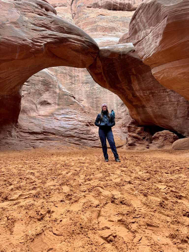
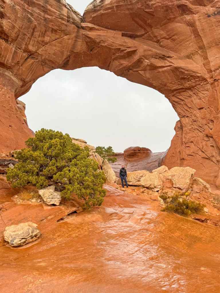
After finishing West Salt Valley Road, our original plan was to do another off-road trail in Canyonlands National Park. However, the weather changed our plans, so we decided to stay in Arches and check out the Sand Dune Arch and Broken Arch Trail instead.
This is a short and easy hike, about 2 miles out and back, that takes you through sandy washes and open desert terrain. Both arches are beautiful and unique—Sand Dune Arch is tucked between sandstone fins and surrounded by soft sand, while Broken Arch is more exposed and dramatic against the sky.
There are restrooms at the trailhead, but the parking lot is small and tends to fill up quickly, especially during busy seasons.
Good to Know:
Just outside of Moab, Utah, you’ll find the vast and rugged landscape of Canyonlands National Park. One of the most fascinating features of this high desert ecosystem is the biological soil crust. Not only is it incredibly expansive, but it also plays a powerful role in keeping the desert alive.
This living crust helps control erosion by holding the soil together in a continuous layer, while also retaining precious water. Plant roots tap into it to survive the dry, hot conditions of summer. Without soil crust, the desert ecosystem would look very different—animals, plants, and even people wouldn’t be able to thrive here.
That’s why it’s so important to stay on marked trails. Even a single footprint can destroy the crust, and damaged areas may never fully recover. If you’re curious to learn more, the NPS has a great resource on Biological Soil Crust.
On Saturday we made the drive out to Canyonlands National Park – The Needles District. This area of the park is remote and much less visited than Island in the Sky. It’s over an hour from Moab, and there’s no cell service, so we strongly recommend downloading offline maps before you go.
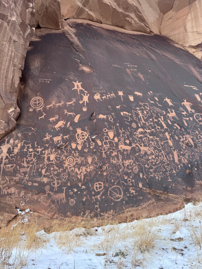
Before reaching the park entrance, we stopped at Newspaper Rock, an incredible archaeological site just off the side of the road. The petroglyphs carved into this rock panel are some of the most well-preserved in the Southwest and offer a glimpse into the history and culture of the Indigenous people who lived here long before it became a national park.
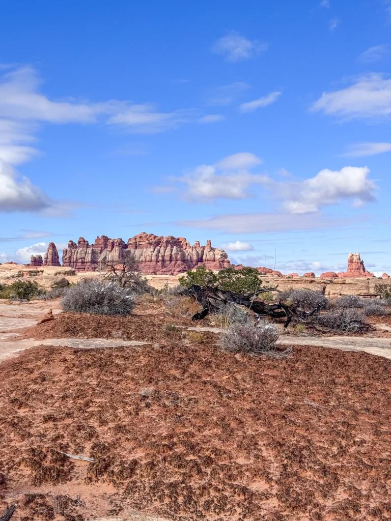
At Canyonlands’ Needles District, we hiked the Chesler Loop Trail starting at the Elephant Hill Trailhead. We recorded 11.2 miles with over 1,900 ft of elevation gain, even though AllTrails lists it at 10 miles.
The first stretch winds through mini canyons, across washes, and along cliff edges before reaching the overlook for Chesler Park. The view here is spectacular — a panorama of the dramatic needle-like formations that give this district its name.
From the overlook, the loop begins. We went clockwise (left), which took us across sandy stretches before flattening out through Chesler Park. Eventually, we reached The Joint, a long, narrow fissure in a massive rock formation. Walking through this crack in the rock is one of the most unique experiences in the park.
After The Joint, the trail follows the Joint Trail, briefly connects with a road near Devil’s Kitchen, and then returns to the main loop. This section was the trickiest to navigate, but cairns (rock stacks) mark the way — keep a sharp eye out for them. Once back at the overlook, the trail reconnects with the out-and-back section leading to Elephant Hill.
This hike was one of our favorite experiences in the Needles District. We loved how remote it felt — often the only sounds were our boots on the dirt, our breathing, and the wind. When we stopped, the silence was unforgettable.
After our hike in Chesler Park, we drove down the Colorado River Overlook Road. We had hoped for a beautiful sunset, but the clouds had other plans. The drive itself ended up being more memorable than the view!
This road was much rougher than we anticipated. You’ll need a high-clearance, 4WD vehicle, and it’s best to air down your tires before heading out. We skipped that step at first and quickly regretted it — once we aired down, the ride was much smoother.
Keep in mind there’s no cell phone service along the road, so be prepared before setting out.
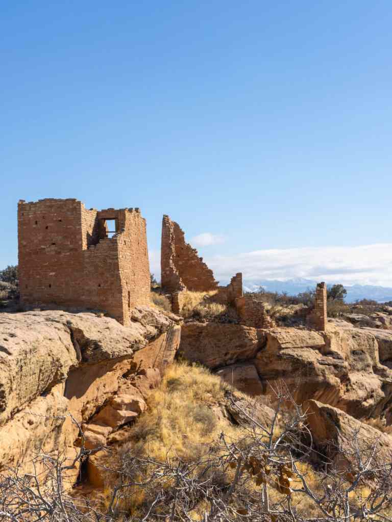
On our way home to Phoenix, we decided to visit Hovenweep National Monument. It added about an hour of drive time to our trip, but it was absolutely worth the stop!
Once home to more than 2,500 people, Hovenweep preserves six prehistoric villages built between A.D. 1200 and 1300. The structures are incredible examples of ancestral Puebloan architecture, perched dramatically on canyon rims.
We hiked the Square Tower Loop Trail, which begins at Canyon Overlook and loops around Little Ruin Canyon. The loop showcases many of the best-preserved towers and dwellings, and the views across the canyon make the trail especially rewarding. There are also other sections of the monument accessible by foot or dirt road if you have more time to explore.
For this trip, we stayed at Field Station – Moab. This renovated hotel is located on the north end of town, just five minutes from the entrance to Arches National Park.
We really enjoyed our stay because the hotel is designed with outdoor enthusiasts in mind. The lobby features a well-stocked gear shop and a cozy coffee bar — perfect for fueling up before an early hike or winding down after a long day exploring.
Stay up to date by subscribing to our mailing list to receive our monthly newsletter and other important updates!
